Summary
The Caribbean
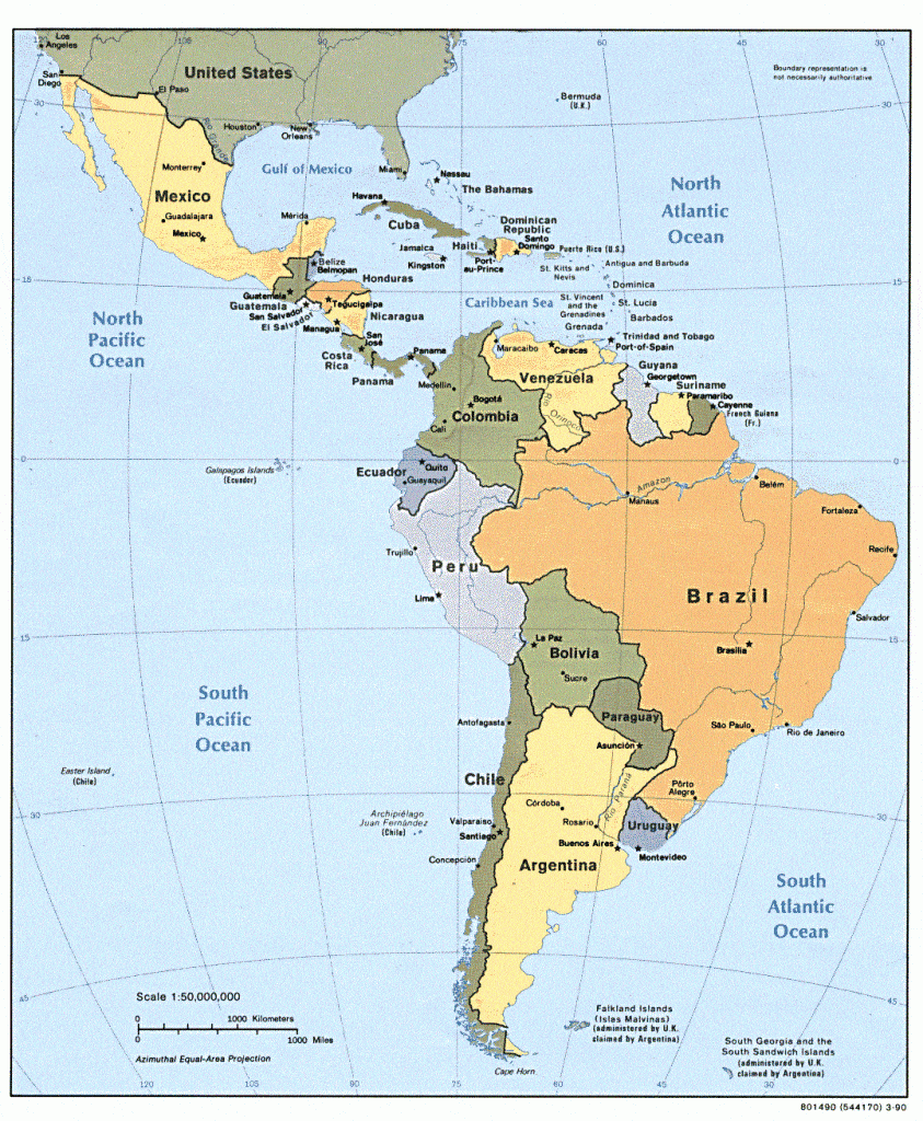
The Caribbean is a region of the world that consists of the Caribbean Sea, the islands of the Caribbean Archipelago, and some countries of South and Central America that borders the Caribbean Sea. It is situated between North America and South America and to the East of Central America. It covers an area of 2,754,000 km2 with a population of 44.2 million. The region has more than 700 islands, islets, reefs, and cays.
The islands arcs comprises of the Greater Antilles on the north and Lesser Antilles on the South and East. They form the West Indies with the nearby Lucayan Archipelago (The Bahamas and the Turks and Caicos Islands (considered to be part of the Caribbean).
On the mainland, Belize, Nicaragua, the Caribbean region of Colombia, Cozumel, the Yucatán Peninsula, Margarita Island, and the Guianas (Guyana, Suriname, French Guiana, Guayana Region in Venezuela, and Amapá in Brazil) are often included.
Water Bodies Surrounding the Caribbean Region
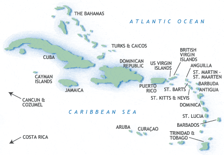
The West Indies
1. The Greater Antilles
The Greater Antilles includes the larger islands: Cuba, Hispaniola (subdivided into the nations of the Dominican Republic and Haiti), Jamaica, and Puerto Rico.
2. The Lesser Antilles
The Lesser Antilles includes the Windward Islands and the Leeward Islands. The Lesser Antilles chain starts in the Virgin Islands and wraps the Eastern Caribbean all the way down to Trinidad and Tobago.
The islands are: The Virgin Islands, Anguilla, St. Martin, Saint Kitts and Nevis, Antigua and Barbuda, Montserrat, Guadeloupe, Dominica, Martinique, Saint Lucia, Saint Vincent and the Grenadines, Barbados, and Grenada; and those of the South American shelf, including Trinidad and Tobago, Aruba, Curaçao, and Bonaire.

Territories of the Central and South America
1. Central America territories
This region is bordered by Mexico to the north, Colombia to the southeast, the Caribbean Sea to the east and the Pacific Ocean to the west and south. Central America consists of seven countries: El Salvador, Costa Rica, Belize, Guatemala, Honduras, Nicaragua and Panama.
2. South America
This region has 14 territories: Ecuador, Columbia, Venezuela, Brazil, Peru, Chile, Uruguay, Paraguy, Argentina, Bolivia, Guyana, French Guiana, Suriname, Falkland Islands.
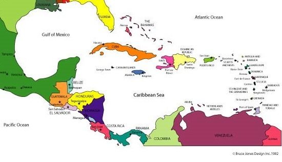
Location of Trinidad and Tobago
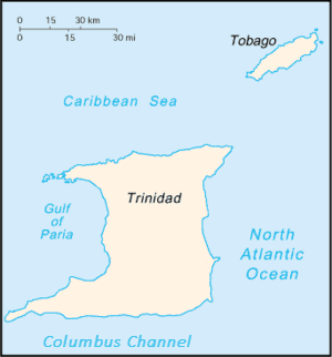
Trinidad and Tobago (which includes the islands of Trinidad, Tobago and several smaller islands). The islands are the southernmost links in the Caribbean chain. Trinidad and Tobago lie close to the continent of South America, northeast of Venezuela and northwest of Guyana.
The area Trinidad is about 1,850 square miles (4,800 square km). It is 7 miles (11 km) from the Venezuelan coast at its nearest point and is separated from it by the Gulf of Paria and two narrow channels. Tobago has an area of about 115 square miles (300 square km) and lies 20 miles (30 km) to the northeast of Trinidad.
Definitions to know:
Gulf – A large body of water, sometimes with a narrow mouth, that is almost completely surrounded by land.
Ocean– a large body of salt water that covers the area between major land masses.
Sea– A body of saltwater, smaller than an ocean and is partially surrounded by land.

Discussion: Describe location of Trinidad and Tobago in relation to four different Caribbean territories.
Worksheet:
Island size in Relation to Direction
Observe the islands in the Caribbean. The Caribbean Archipelago shows the increasing size of the islands northwards (up) from Tobago to Cuba. The further up, more northwards, you get further from Trinidad and Tobago.
Worksheets
Click on the links below to download the PDF worksheets.

